
Harvest, not conversion: a Cameroonian cutting block read from 2020 to 2025
A tree-cover loss alert fires on a selective harvest and on a clearance alike. Read pixel by pixel from the JRC record, a real annual cutting area harvested in 2021 was still 98 per cent undisturbed forest at the end of 2025, with no ground cleared.
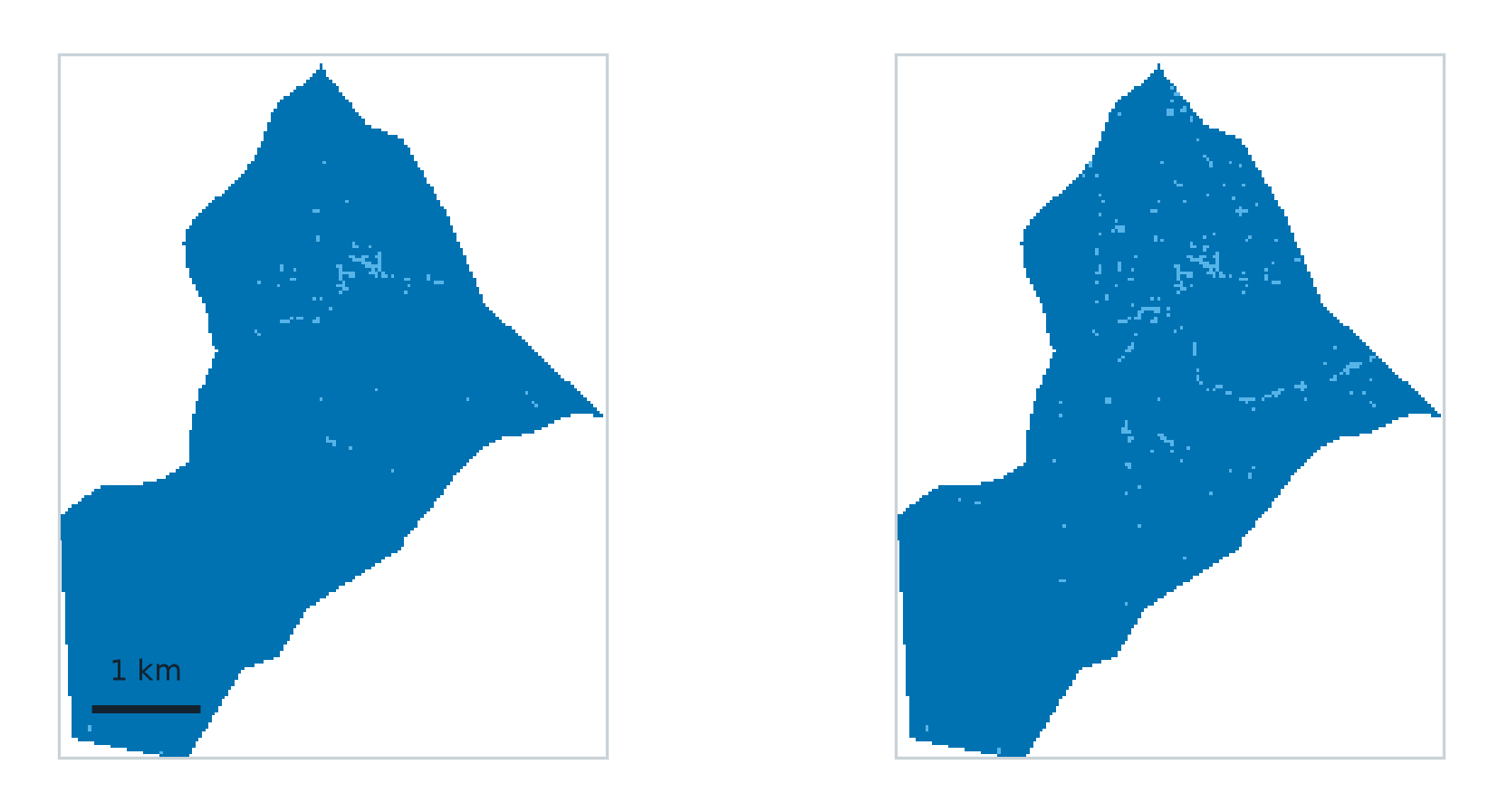
- Block
- A MINFOF annual cutting area
- Harvested
- During 2021
- Read at
- End of 2020 and end of 2025
- Pixels in the block
- 15,901
- Undisturbed, 2020
- 99.3%
- Undisturbed, 2025
- 98.1%
- Cleared land
- None, either year
- Outcome
- Forest retained after harvest
The problem
An importer placing tropical wood on the EU market has to show that the harvest behind a shipment left the forest standing, and a loss alert cannot tell a harvest from a clearance.
What we did
Each pixel's forest class in the JRC Tropical Moist Forest record read at the cutoff and again at the end of 2025, over the whole block.
The result
98.1 per cent still undisturbed forest five years on, the rest disturbed canopy that never cleared, and the outcome forest retained after harvest.
Overview
For wood, the EU Regulation asks two things of a harvest block. Was it forest on 31 December 2020, and after the harvest is it still forest, or has it become something else. A selective harvest that takes a few stems a hectare and leaves the canopy to close is the first case. A clearance for a plantation or a farm is the second.
This case reads a real annual cutting area from the Cameroon Ministry of Forests and Wildlife's Forest Atlas, harvested during 2021, the way an importer would need it read for a shipment file. It is one of the control blocks behind the harvest block record, not a customer's block.
The challenge
A tree-cover loss alert marks where the canopy fell. A selective harvest and a clearance both trigger it, so an alert on a cutting block says only that something happened, and an importer with a concession's worth of blocks behind a shipment cannot send someone to each one.
What the importer needs is the outcome per block, read from a public record, with every source named in a form that can go into the statement.
What we did
The JRC Tropical Moist Forest record, built from the whole Landsat archive, gives every 30-metre pixel a forest class for each year. Each of the block's 15,901 pixels was read at the end of 2020, the Regulation's cutoff, and again at the end of 2025, the record's last mapped year.
The question asked of each pixel is simple: did it stay forest, or did it become cleared land.
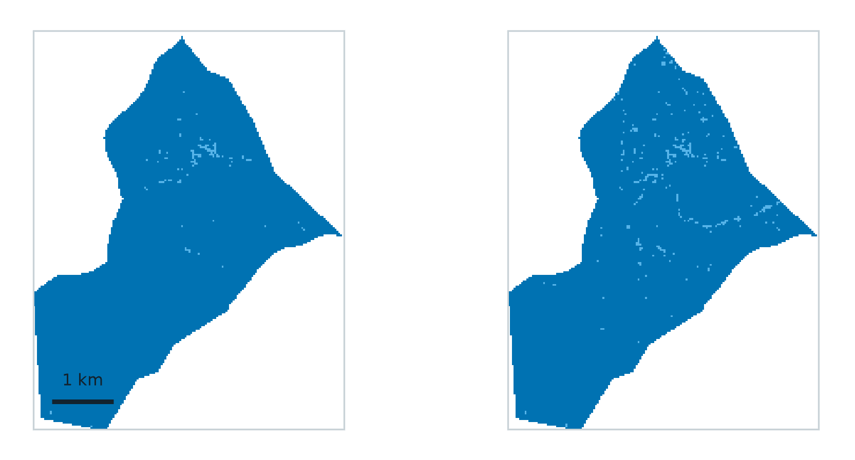
What the record showed
| End of 2020 | End of 2025 | |
|---|---|---|
| Undisturbed forest | 99.3 per cent | 98.1 per cent |
| Disturbed canopy, not cleared | 0.7 per cent | 1.9 per cent |
| Cleared land | none | none |
| Regrowth | none | none |
Five years after the cutoff, and four years after the harvest, 98.1 per cent of the block still reads as undisturbed forest. The 1.9 per cent of disturbed canopy runs in thin lines through the block, the shape roads and skid trails leave. No pixel reads as cleared land.
That is the pattern a selective harvest leaves, and the block record states it as its outcome: forest retained after harvest.
What it means
For an importer, the block record gives the outcome per block and every source behind it, ready for the shipment file. The block carries onto the shipment with its species, and the shipment report lays the block pages out in the Information System's wood field order.
The record is measured. On a fresh set of control blocks held out from the rule's design, 19 of 19 harvest blocks received a finding and 0 of 18 blocks converted to another use did, across Brazil, Cameroon, Indonesia and Malaysia.
Run this on your own ground
Draw an area of interest, pick the dates, and the same analysis runs against the archive over your sites.
References
- Axine Labs (2026). Harvest or conversion: a per-block record for wood placed on the EU market. Sections 3 and 4.
- Vancutsem C., Achard F., Pekel J.-F. et al. (2021). Long-term (1990 to 2019) monitoring of forest cover changes in the humid tropics. Science Advances 7(10), eabe1603. doi.org/10.1126/sciadv.abe1603
- Ministère des Forêts et de la Faune, Cameroon, and World Resources Institute. Forest Atlas of Cameroon. cmr.forest-atlas.org
- Regulation (EU) 2023/1115 of the European Parliament and of the Council, Article 2.
More case studies
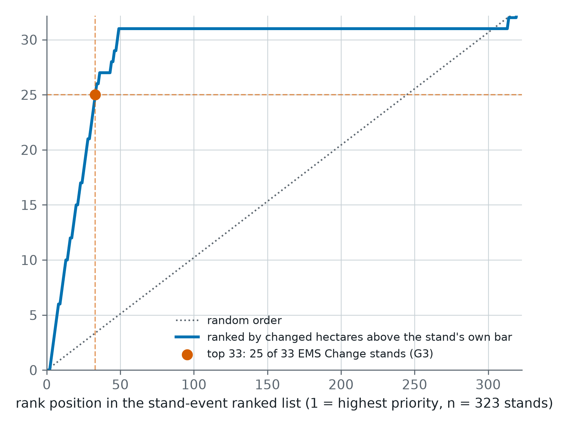
Storm Johannes: which stands to visit first, ranked from open imagery
After the December 2025 storm in central Sweden, 323 test stands were ranked from Sentinel-1 and Sentinel-2. Of the 33 the storm had changed, 25 sat in the top 33 of the list. Random order would have put three or four there.
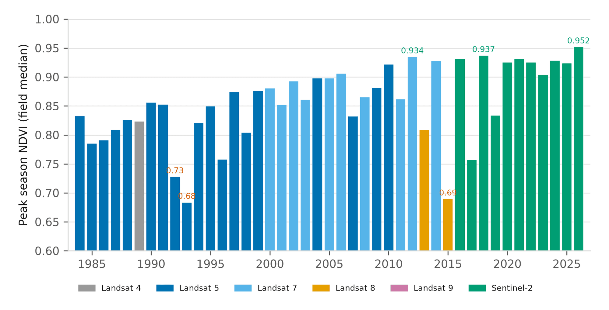
Forty-three seasons of one Nebraska pivot, and its first zone map
Before driving out, an agronomist wants to know whether this season is unusual for this field, not for the county. One centre pivot near Seward has a reading for every season from 1984 to 2026, and 2026 is the highest of them.
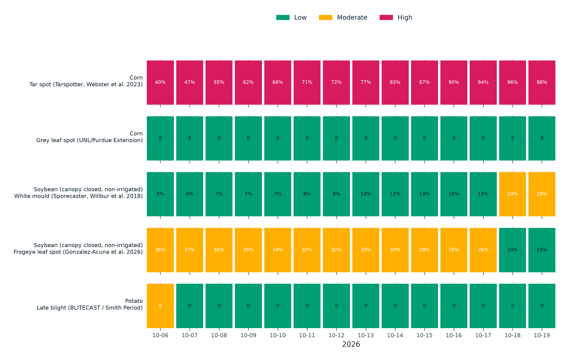
A Kansas season on one page, and the next two weeks of disease pressure
A 61-hectare corn pivot in western Kansas, 184 days into the 2026 season: 53 days at or above 35 °C against a normal of 27.8, more heat units than usual, and five published disease models run on the field's own forecast.