Two Kabylie fires, two years apart, sharing only 334 hectares
Kabylie burned catastrophically in 2021 and again in 2023. Both fires were mapped and neither was followed. Eight archive scenes put the two burns at 19,106 and 18,853 hectares, their overlap at 334, and the first scar back to indistinguishable from unburned forest in four summers.
- Site
- Béjaïa, Kabylie, Algeria
- Area analysed
- 1,244 km²
- Scenes used
- 8
- Controls
- 1,841 ha and 489 ha
- 2021 burn
- 19,106 ha
- 2023 burn
- 18,853 ha
- Reburn
- 334 ha, 1.9%
- 2021 scar recovered
- 99% in four summers
The problem
Three studies exist for the 2021 fires and none for 2023. No published recovery series, no reburn analysis, and no comparison between two fires that each took about thirteen thousand hectares of the same wilaya.
What we did
Each fire scored against the summer before it at the published Key and Benson threshold, with five anniversary scenes on one orbit and recovery measured against 75,151 hectares of unburned ground in the same scene.
The result
Two fires of almost identical size sharing 334 hectares, a scar closed to unburned forest in four summers, and a fuel break effect that did not survive its own control.
Overview
Northern Algeria burned catastrophically in August 2021 and again in July 2023, and both times the fires ran through the same corner of the Béjaïa coast.
The 2021 fires were the worst Algeria had recorded in more than a decade. The forestry directorate put the national burned area at 100,101 hectares across 1,631 outbreaks in 21 wilayas. The European Forest Fire Information System, mapping independently, put it at 134,273 hectares, 69 per cent of everything that burned across North Africa and the Middle East that year. More than a third of the Algerian total was mountain fruit trees, fig and olive: the standing capital of these hills rather than a crop that can be resown next spring. At least 90 people were killed, 33 of them soldiers. In Béjaïa the toll included four people at Taâzibt, above Barbacha, who died trying to save their beehives.
Fire returned on the night of 23 July 2023, starting at El Kseur and Beni K'sila. At about four the next morning, as an army detachment was evacuating its own personnel together with the residents of the surrounding mechtas, the wind turned onto their position and killed ten soldiers and wounded twenty five. Eighteen civilians died in the wilaya that day. The wali evacuated 1,400 people.
This study covers 1,244 square kilometres straddling the boundary of Béjaïa and Tizi Ouzou: the Adekar, Akfadou and Toudja massifs, which Béjaïa's forest service named as the single continuous block worst hit in 2021, and Beni K'sila, where most of the 2023 dead were.
The challenge
The published record for this terrain is entirely about extent and severity in the weeks after the flames. Three studies exist for 2021: a severity map of Tizi Ouzou, a Béjaïa severity preprint, and a two wilaya extent assessment. For 2023 there is not one. For either year there is no published recovery time series, no reburn analysis, and no comparison between the two fires at all.
International mapping was real, and it was inverted between the two events. August 2021 drew an activation from the European emergency mapping service, EMSR533, opened on 11 August and the only Algerian activation in the history of that service, but no International Charter call. July 2023 drew the opposite: Charter activation 831, requested by the Algerian civil protection with the space agency as project manager, and no European activation. The UN satellite centre worked both, but in 2021 published hotspot density rather than burned area, and only in 2023 delineated what had actually burned.
Almost none of what burned was insured, and the industry's own accounts show it. Algeria's agricultural risks branch wrote 2,157 million dinars of premium in 2021, 1.6 per cent of all damage insurance, and paid 923 million in claims. That is 16.1 per cent less than the 1,100 million it paid in 2020. In the worst fire year in over a decade, the national agricultural insurer's claims went down.
The gap is take-up rather than product. The mutual that holds 65.1 per cent of the branch already sells fire cover for orchards, fruit trees and beehives, but the director of its Tizi Ouzou arm said in 2017 that orchard cover there does not exceed 3 per cent, and orchards are precisely what burned. Algerian law does not treat wildfire as a natural catastrophe, so the mechanism built for those does not respond to it.
The state paid instead, largely in kind: a million dinars to the family of each victim, 700,000 for a destroyed home, and for farmers no cash indemnity at all. Compensation came as livestock and saplings. A year on, 18,256 farmers had been compensated across the two worst hit wilayas, 4,160 of them in Béjaïa, for about 2.6 billion dinars, and Béjaïa had been planted with 146,934 fruit trees of which 113,291 were olives.
Loss assessment here was already a remote sensing problem and Algeria already knew it. The wilaya commissions that valued the damage used satellite imagery alongside farmers' declarations, working with the national space agency. What none of that answered is the question that follows a payout: how long the ground takes to come back, and whether the next fire will burn the same place.
What we did
Two separate analyses run over the same 1,244 square kilometres, on a box drawn once and never moved.
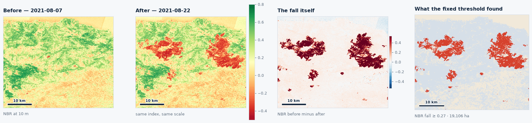
Each fire is scored against the summer before it. The 2021 burn runs from 7 August 2021 against 22 August 2021, the 2023 burn from 20 July 2023 against 22 August 2023. Scoring the second fire against the first fire's baseline would count the older scar twice and turn a reburn question into an arithmetic artefact.
The test is the one already published, applied unchanged: ground counts as burned where the normalised burn ratio falls by 0.27 or more, the Key and Benson reference break, the same value the Jasper study used against Canada's national burn composite. Nothing was tuned to Algeria. Scoring runs only over ground that carried vegetation beforehand, which keeps bare limestone and the sea out of the mask.
Every date in the recovery trajectory sits exactly 365 days from the last: 22 August 2021, 2022 and 2023, then 21 August 2024 and 2025. All five scenes therefore fall on the same relative orbit, with identical viewing geometry and sun angle, so a five year comparison needs no correction for reflectance geometry anywhere in it.
Recovery is measured against unburned ground in the same picture rather than against the past. Inside the box, 75,151 hectares carried vegetation before both fires and burned in neither. Each year the measurement is the gap between the median burn ratio inside a scar and the median outside it, in the same scene on the same day, which subtracts out the rainfall year, the phenological stage, the sun angle and the atmospheric correction. An index that rises in a wet summer is telling you about the summer.
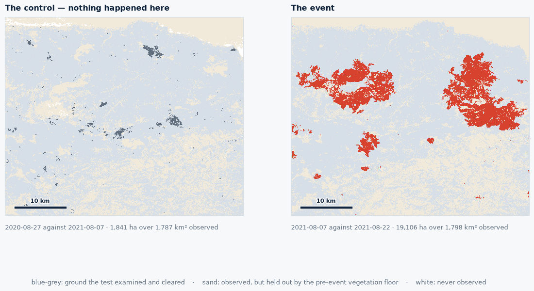
Ground that burned twice is removed before either trajectory is computed, so a reburned pixel cannot count as a slow recovery in one fire and a deep burn in the other. And the same test runs where nothing burned: between August 2020 and August 2021 it returns 1,841 hectares, between August 2022 and July 2023, 489. Every number below is read against those.
What the imagery showed
| fire | baseline | post-fire scene | ground observed | burned area | largest scar | control |
|---|---|---|---|---|---|---|
| August 2021 | 7 Aug 2021 | 22 Aug 2021 | 1,244 km² | 19,106 ha | 10,009 ha | 1,841 ha |
| July 2023 | 20 Jul 2023 | 22 Aug 2023 | 1,226 km² | 18,853 ha | 15,603 ha | 489 ha |

Both fires exceed their control by more than an order of magnitude. Two agencies mapping the 2023 fire independently land beside these figures rather than away from them: the UN satellite centre found about 18,000 hectares of burned vegetation over a 540 square kilometre window on 25 July, and the European fire information system recorded the biggest fire of its year at over 14,000 hectares in the Béjaïa region against our largest single connected scar of 15,603. The windows and boundaries differ, so neither is a like-for-like score, and neither was consulted before the run.

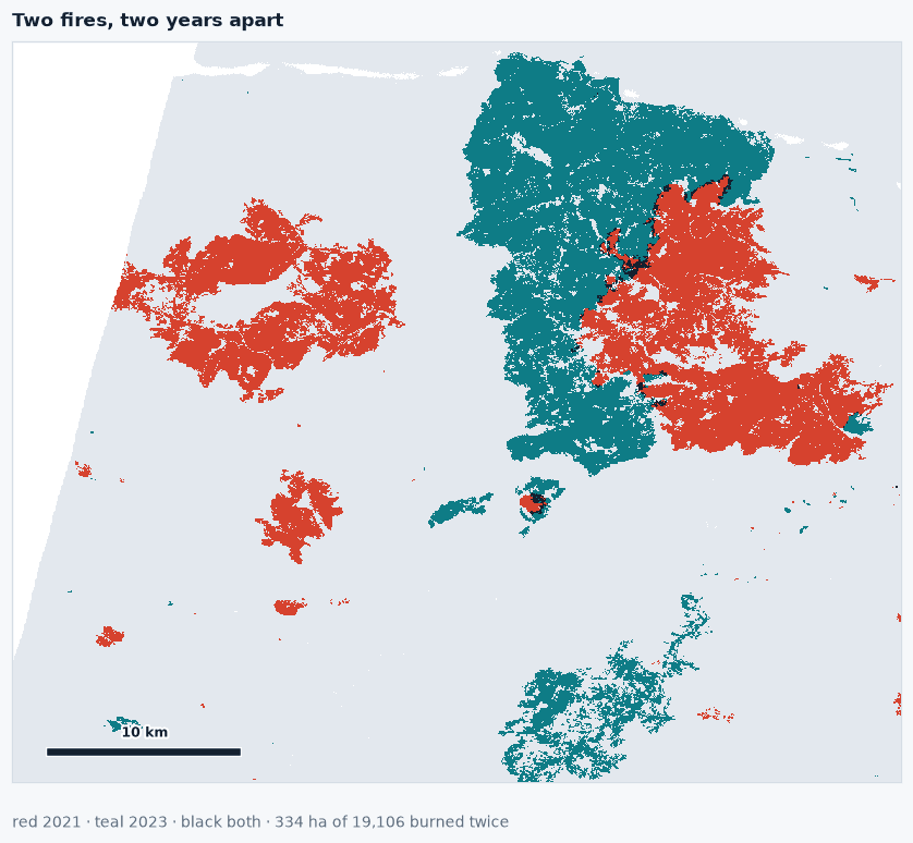
Two fires of almost identical size, two years apart, in the same 1,244 square kilometres, and they scarcely touched. Whatever drove the 2023 fire, it was not fuel left standing by the 2021 one.
Drawn together, the two burns abut along a north to south line, which reads immediately as a two year old scar acting as a fuel break. Measured against the ground the 2023 fire could have burned instead, the 75,151 hectares of vegetated, twice unburned land in the same box, that reading does not hold. The 2023 scar sits at a median 2,478 metres from the 2021 scar against the pool's 2,192, and it is less likely than chance to fall within 100 metres of it, 2.2 per cent against 4.4. At the scale this box resolves, the old scar neither drew the new fire nor blocked it. The appearance is two large patches in a small area.
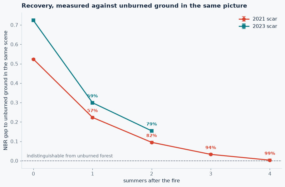
| summers after the fire | 2021 scar | closed | 2023 scar | closed |
|---|---|---|---|---|
| 0, the fire itself | 0.524 | 0.723 | ||
| 1 | 0.223 | 57% | 0.299 | 59% |
| 2 | 0.095 | 82% | 0.154 | 79% |
| 3 | 0.033 | 94% | ||
| 4 | 0.003 | 99% |

The 2021 scar closed its gap to unburned forest in four summers. At four summers the 95 per cent interval on that gap runs from −0.003 to +0.009 and contains zero: the canopy signal over that ground is no longer separable from forest that never burned. Published Mediterranean recovery times run from about two years in northwest Spain to roughly four in Portuguese seeder dominated shrubland and nearly six in Catalonia, and the closest Algerian analogue, the Dahra forest in the northwest, recovered in two years after its 2012 fire and nine after its 2000 one.
The 2023 fire burned deeper but recovers at the same rate. Its opening gap is 0.723 against 0.524, 38 per cent more severe on identical settings, and measured 30 days after ignition against the 2021 fire's 13, so the difference is if anything understated. After one summer it had closed 59 per cent of that gap against the older fire's 57, and after two summers 79 against 82. The 2023 scar is not recovering slowly. It started further down.
Tracking the identical scars on the vegetation index instead of the burn ratio gives 47, 79, 91 and 98 per cent for 2021 and 55 and 77 for 2023, with the 2021 interval containing zero there too. The published comparison of these two index families finds burn ratio measures report systematically slower recovery than vegetation index ones over the same pixels. Ours agree to within two points, in the direction that literature predicts.

One more thing the series shows. In August 2021 the fire is a single connected patch of 10,009 hectares. One year later the largest connected patch inside the same footprint is 462 hectares, across 719 fragments. The window in which a fire of this kind reads as one coherent object in imagery is about one growing season wide.
What it means
For an insurer or a development bank pricing this ground, the reburn result is the commercially useful one. Two catastrophic fires in the same massif two years apart shared 1.9 per cent of their area, and the older scar showed no measurable protective effect on where the newer fire ran. A risk model that discounts recently burned ground would have been wrong here, and the evidence to check that is eight archive scenes rather than a field campaign.
The recovery result is the one that matters for a compensation programme. Four growing seasons after a burn of this severity the canopy signal is back to indistinguishable, which sets a defensible outer bound on how long replanting support needs to run. What it does not set is a yield date. A closed burn ratio gap means the ground reflects like unburned vegetation. It does not mean the same species came back, that cork oak is again strippable, or that an olive grove is again in production. Mediterranean systems resprout fast, which is precisely why the optical signal closes fast, and on ground where a third of what burned was fig and olive that distinction is the whole commercial question.
Two things bound how far these numbers travel. Only 334 hectares are common to both fires, so the severity comparison carries a confound: the 2023 fire being 38 per cent deeper may be the fire, or it may be that the western hills carry different fuel from the eastern ones. The recovery rates are the sounder half of the comparison, because each scar is measured against its own starting point. And this is one scar, one region, one climate sequence, so a drier run would give a different curve.
The extent figures rest on a validation done elsewhere. No Algerian agency publishes a per fire perimeter to score against, so they carry across from Jasper, where the same threshold landed 6.5 per cent below Canada's national burn composite without being tuned to that fire, supported here by the control and by two agencies that mapped the 2023 fire independently. The recovery and reburn findings depend on none of that: both are internal comparisons against unburned ground in the same scenes.
Run this on your own ground
Draw an area of interest, pick the dates, and the same analysis runs against the archive over your sites.
References
- Direction Générale des Forêts, national burned area statistics for 2021.
- European Forest Fire Information System, Joint Research Centre, annual reports 2021 and 2023.
- UN Satellite Centre, product 3644, Béjaïa wildfire delineation, 25 July 2023.
- International Charter Space and Major Disasters, activation 831, requested by the Algerian civil protection, July 2023.
- Conseil National des Assurances, agricultural risks branch statistics, 2020 and 2021.
- Key C.H. and Benson N.C. (2006). Landscape assessment: sampling and analysis methods. FIREMON, USDA Forest Service RMRS-GTR-164-CD.
- Companion study: mapping the Jasper burn scar, where the same threshold is scored against Canada's National Burned Area Composite.
More case studies
Mapping Vaia windthrow when salvage was a race against the timber's own value
The Vaia storm flattened 42,525 hectares of Alpine forest and collapsed the roundwood market. Salvage depended on reaching the right stands first, and the emergency mapping activation covered under a tenth of the damage.

Mapping the Jagersfontein tailings flow five days after the dam broke
A diamond mine tailings dam failed in the Free State and buried working farmland. Three years on, no footprint of it had been published, and the two area figures in the literature disagree by a factor of 1.6. We mapped it from five archive passes.

Measuring the 2022 Po drought against Italy's own rice loss survey
In July 2022 the Po fell to an eighth of its normal flow. We measured the collapse across the Lomellina rice district at the threshold Italy's rice authority uses, and put the result beside the hectares they published.