
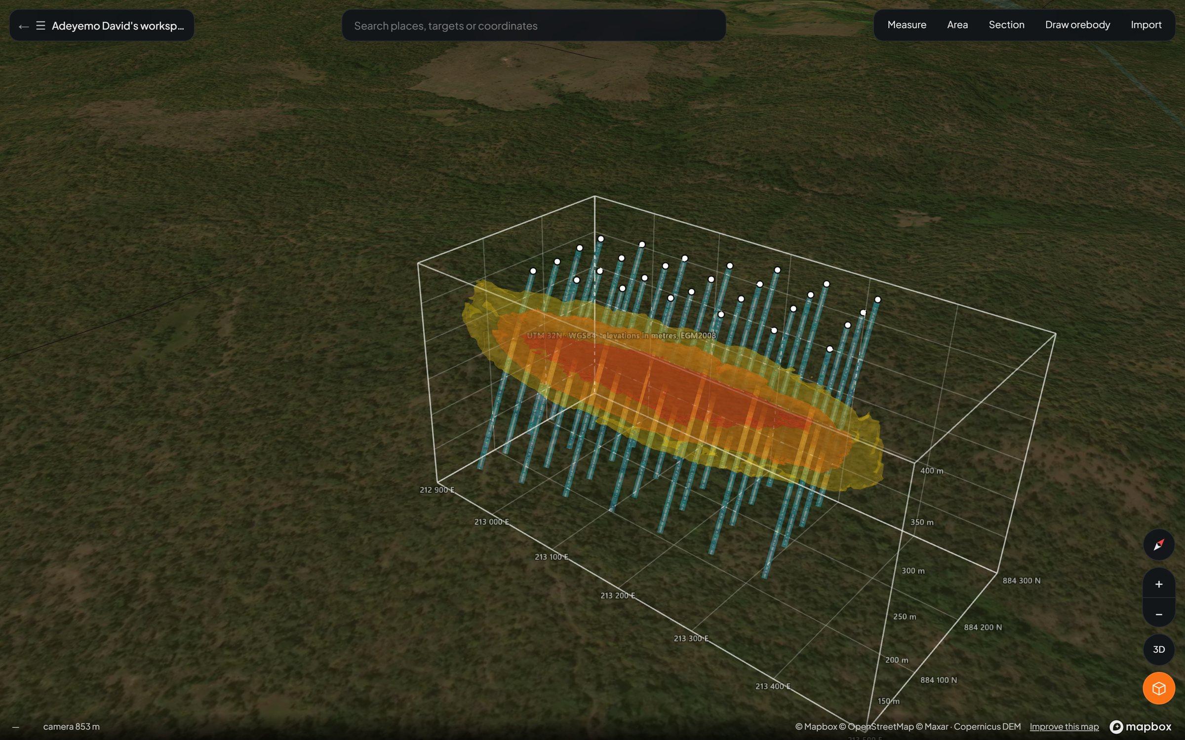
Axine Labs has launched the Lisaris 3D Explorer, an integrated three-dimensional geological workspace built directly into the Lisaris platform for mineral exploration and resource development teams. The release brings satellite alteration layers, airborne geophysics, drillhole databases, and 3D orebody interpolation into a single zero-install environment.
Mining teams typically operate across a fragmented software stack: satellite targeting lives in one portal, field station logs sit in spreadsheets, and subsurface drillhole modelling requires expensive, heavyweight desktop installations. That fragmentation slows down decision-making between field campaigns and keeps critical geological context locked on individual workstations.
The Lisaris 3D Explorer unifies the entire exploration workflow on a 3D globe anchored by Copernicus 30-metre digital elevation terrain, shaded relief, and high-resolution satellite imagery. Exploration teams can drop their existing KML, KMZ, and GeoJSON boundaries directly onto the terrain alongside subsurface geophysics and live drilling data.
A Unified Subsurface and Surface Stack
- Drillhole Architecture: Teams import collar, survey, and assay tables via standard CSV exports straight from their drilling databases. Lisaris automatically desurveys traces in 3D space and renders downhole assay intervals by grade.
- Subsurface Geophysics: Magnetic grids drape directly across the topography while 3D susceptibility isosurfaces from geophysical inversions sit at true depth beneath the surface.
- Dynamic Cross-Sections: Geologists can slice section lines across any corridor to inspect the terrain profile, intersected orebody solids, drillhole traces, and nearby surface stations simultaneously.
- Mobile Field Integration: Field geologists log outcrop stations, including handheld magnetic susceptibility, rock density, structural measurements, sample IDs, and field photography, directly from mobile devices in the field, syncing immediately to the 3D globe.
Three Pathways to 3D Orebody Modelling
- Surface Outcrop Extrusion: Geologists trace mineralised outcrops at surface and define variable thickness, dip, and depth extent along strike, allowing modelled bodies to naturally swell and pinch out as mapped in the field.
- Section Lofting: Teams outline mineralised zones across two or more parallel cross-sections, which Lisaris automatically lofts into closed 3D geological solids.
- 3D Assay Interpolation & Grade Shells: Downhole assays are interpolated in three dimensions and contoured across up to six user-defined cut-off grades into nested grade shells. Each shell automatically computes volume, rock tonnage, mean grade, and contained metal, guided either by a structural trend set by the geologist or fitted mathematically to the ore samples.
In pre-release validation against synthetic drilling programmes with known subsurface geometries, the Lisaris interpolation engine recovered true structural dip and azimuth within 3 degrees and estimated primary ore envelope tonnage within 10 percent of ground truth. All modelled solids sit inside a UTM-calibrated coordinate cage and export cleanly to KML, CSV, and OBJ formats for direct interoperability with Leapfrog, Micromine, and Datamine. Modelled solids serve as rapid geological interpretations to guide exploration and drilling rather than formal Mineral Resource statements.
"Geologists shouldn't have to wait until they are back at a workstation license in the capital to see how today's field structural readings or assay returns change the shape of the orebody," said David Adeyemo, Founder and CEO of Axine Labs. "With the Lisaris 3D Explorer, the satellite alteration target, the magnetic inversion at depth, and the 3D grade shells live in the same browser tab."
The Lisaris 3D Explorer is already deployed in active operations across Axine Labs' 18,000 km² targeting programme in North-Central Nigeria. Mining teams can request workspace access via axinelabs.com/contact.
About Axine Labs
Axine Laboratories Inc. (Axine Labs) is an applied spectroscopy and geospatial intelligence company building Lisaris, the autonomous earth observation platform that turns multispectral, hyperspectral, and radar satellite streams into deterministic, audit-grade records. Operating across 100 specialized physical and machine learning models, Lisaris powers mineral exploration targeting, 3D subsurface modelling, EUDR supply chain compliance, infrastructure monitoring, and agricultural intelligence for operators across Africa, Latin America, Asia, and Europe. For more information, visit www.axinelabs.com.
Media & Commercial Enquiries: contact@axinelabs.com