
Storm stand record
After a named storm, a snow load or a beetle season, every stand on the estate is read from the open Sentinel archives against its own quiet years and ranked by where the change is largest. Your claims team knows which stands need a visit, and your members have the estate record.
For forest insurers’ claims teams and the loss adjusters working with them, and for owner associations and management firms that need the estate’s record of the event.
- Events
- Storm, snow, beetle, fire
- Languages
- English, Swedish, Norwegian
- Delivered as
- PDF, CSV, map layers
- Price
- Quoted on request
01 · The order
What you send, and what comes back
You send
- Stand boundaries as exported from your forestry system, or one estate boundary we cut into cells
- The event: its name, kind and date
- A claim reference for each stand, where there is one
You receive
- A ranked list: each stand’s status against its own quiet range, the changed share, and the archive that decided it
- A map of stands by status, with before and after Sentinel-2 images for each stand
- A stand record and an estate record as PDF, under your name or your association’s
- A visit list as CSV with stand centre points, ready for a drone flight plan
- Records in English, Swedish or Norwegian, with area in dekar for Norwegian records
02 · How it is read
From the open archive to the record
Public sources
- 01
Each stand is compared with its own quiet years, not with a rule for the whole forest, so a stand that always changes a little is not mistaken for storm damage.
- 02
The record dates and ranks a change. It does not name a cause or give a share of timber lost; that is what the visit is for.
03 · The record behind it
What it has been measured against
Each figure is printed with its denominator and scope in the paper it links to.
- 25 of 33
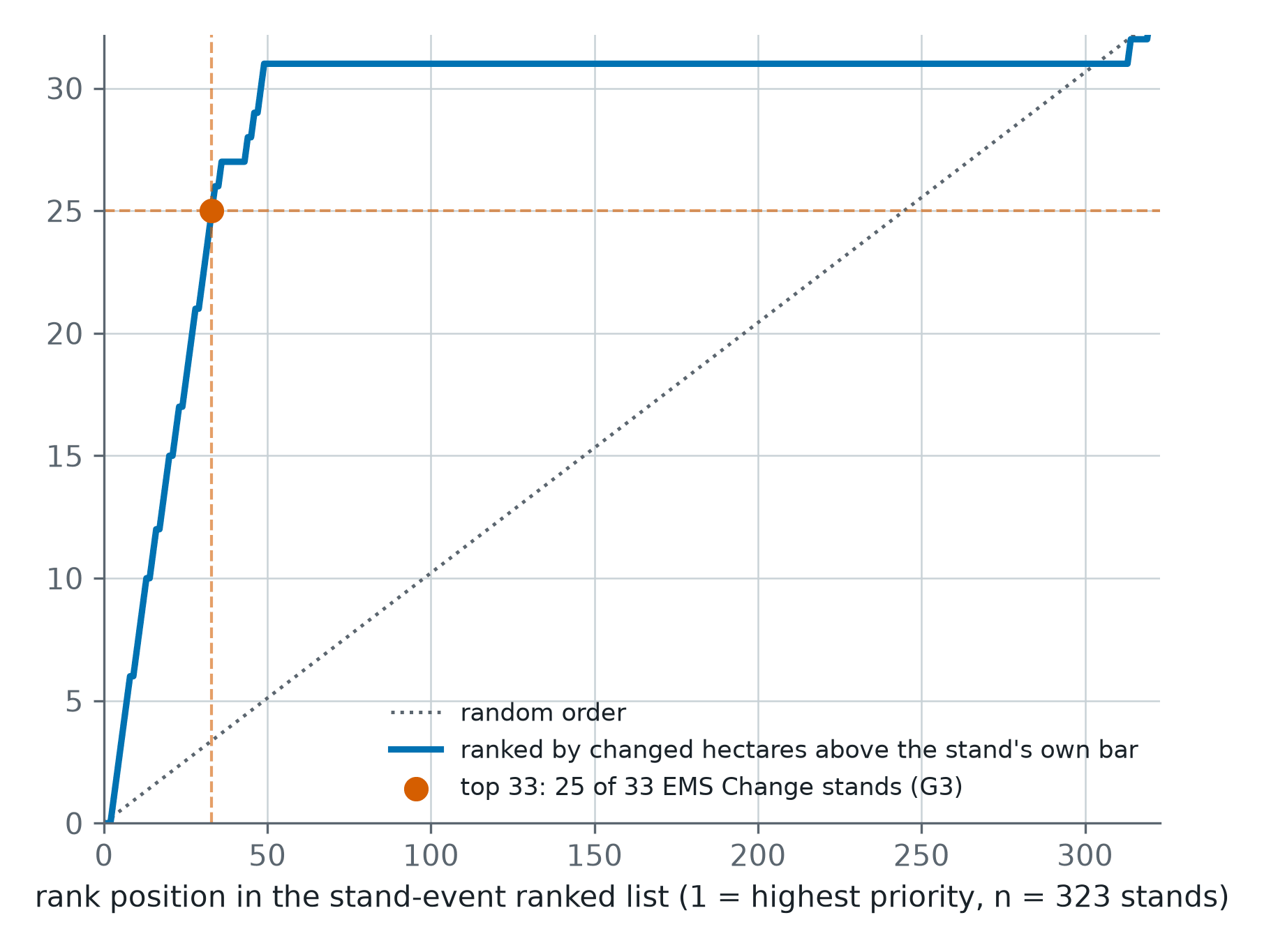
- stands changed by Storm Johannes placed in the top 33 of a 323-stand ranked list; random order would place three or four
- 28 of 33
- changed stands called above their own quiet range, read against the Copernicus EMS grading of the storm
Forest records from open satellite archives, Axine Labs, 2026
Forest records from open satellite archives, Axine Labs, 2026
More in EUDR and forestry
Plot evidence
One evidence document per plot: what the open record shows stood on the ground in each dry season before the cutoff.
Archive imagery review
For plots the open record could not settle, a named reader files a dated reading of a sub-metre scene from before the cutoff.
Cases
Every withheld plot and every alert is worked as a case, with an append-only record you can show a competent authority.
Supplier requests
Ask a supplier for boundaries, planting records or a land title through a link that needs no account, and import what comes back.
Shipments and statements
Group the plots behind a consignment, get the shipment report, and export the statement in the Information System’s field order.
Evidence pack and share links
Hand one plot’s evidence to a buyer, a platform or an auditor: a PDF and ZIP pack, and a revocable link that needs no sign-in.
Send us ten flagged plots
Send the boundaries of ten plots your screen flagged. The record comes back within 48 hours as a PDF with the layers, each plot with its finding or its reason and next step.