
Settle the flagged plot with a dated record
For each plot on your register, the open satellite record is read over every dry season before 31 December 2020 and filed as the document an inspector asks for. Where the open record stops short, a named reader looks at a sub-metre scene from before the cutoff.
01 · Who it is for
The people who file, settle and advise
Operators and traders
Heads of sustainability, purchasing and responsible sourcing who file under Regulation (EU) 2023/1115 and need the evidence behind each plot.
Due-diligence platforms
Platforms that file for many operators and want the evidence under their own screens, through the API and signed webhooks.
Tropical wood importers
First placers who need a harvest record per cutting block, and a statement laid out in the Information System’s order.
Forest insurers and associations
Claims teams and owner associations that need a dated record of every stand after a storm, ranked by where to send a forester first.
30 December 2026
Large and medium operators apply the Regulation from this date. Every plot behind a statement needs geolocation and the evidence that it was not cleared after the cutoff.
Cocoa on ICE
From 30 December 2026, London cocoa grading applications need validated due diligence information. Transition stock without it is discounted GBP 100 a tonne.
Trade Informer, ICE cocoa delivery rulesHow authorities check
Germany’s competent authority, the BLE, uses high and very high resolution satellite data in its own checks on operators.
BLE, checks under the EUDR02 · Products
What you can order
Each product is ordered over your own plots, fields, stands or assets, and comes back as a document and a set of map layers.
Plot evidence
One evidence document per plot: what the open record shows stood on the ground in each dry season before the cutoff.
Archive imagery review
For plots the open record could not settle, a named reader files a dated reading of a sub-metre scene from before the cutoff.
Cases
Every withheld plot and every alert is worked as a case, with an append-only record you can show a competent authority.
Supplier requests
Ask a supplier for boundaries, planting records or a land title through a link that needs no account, and import what comes back.
Shipments and statements
Group the plots behind a consignment, get the shipment report, and export the statement in the Information System’s field order.
Evidence pack and share links
Hand one plot’s evidence to a buyer, a platform or an auditor: a PDF and ZIP pack, and a revocable link that needs no sign-in.
Storm stand record
After a storm, a dated record of every stand, ranked by where to send a drone or a forester first.
Harvest block record
A record per cutting block: forest at the cutoff, and still forest after the harvest. Laid out for the statement.
EUDR area analysis
Forest at the cutoff and recorded change since, over a sourcing zone or concession, with every plot on it read the same way.
Forest cover change
Forest cover at a start date, and the loss and gain between two dates, with the Landsat trajectory behind it.
Burnt area and damage degree
The burnt extent of a fire and its damage degree in five classes, with hectares and shares, for owners and claims desks.
Forest health
Where a stand reads below its own recent years at the same time of year, in decline and confirmed decline classes.
Tree species
Dominant tree species over an area, from your own species polygons or the national species map where one exists.
03 · What comes back
A document you can forward, and the layers behind it
- 01A plain-word state on every plot: a finding, a withheld result with its reason, or supporting evidence
- 02An evidence document per plot, with one true-colour look per season, the pre-cutoff season table and every source
- 03A book summary of the whole register on one page, for the person who files
- 04An evidence pack and a revocable share link that opens without an account
- 05Statement fields in the Information System’s order, ready to file from your own TRACES account
- 06The same record as JSON, with signed webhooks when a batch lands
04 · The record behind it
Measured on control sets, counted plot by plot
Every figure below is printed with its denominator in a dated paper. Each one links to the document it comes from.
- 0 of 220
- natural forest control blocks, across five regions, given a finding of an established stand
- 51 of 65
- established crop control blocks in Côte d’Ivoire that reached a finding, estates from four hectares
- 70 of 91
- forest control blocks in the cocoa belt holding a low-cloud sub-metre scene dated 2016 to 2020
- 25 of 33
- stands changed by Storm Johannes placed in the top 33 of a 323-stand ranked list
- 19 of 19
- held-out harvest blocks in Brazil, Cameroon, Indonesia and Malaysia that received a finding
- 0 of 18
- held-out blocks converted to another land use after the harvest that received a finding
Forest records from open satellite archives, Axine Labs, 2026
05 · Case studies
Read on real ground
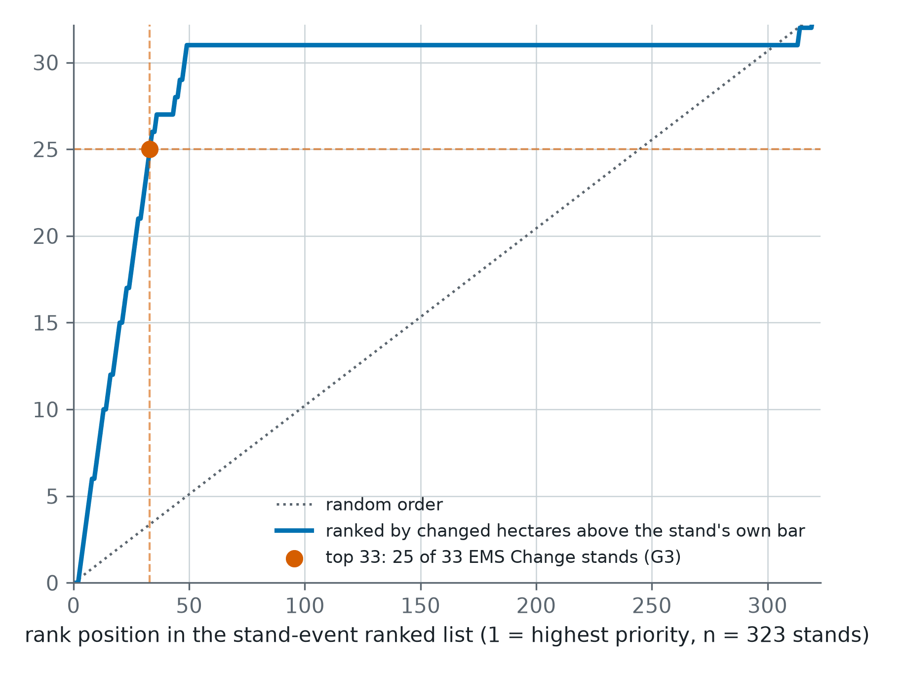
Storm Johannes: which stands to visit first, ranked from open imagery
After the December 2025 storm in central Sweden, 323 test stands were ranked from Sentinel-1 and Sentinel-2. Of the 33 the storm had changed, 25 sat in the top 33 of the list. Random order would have put three or four there.
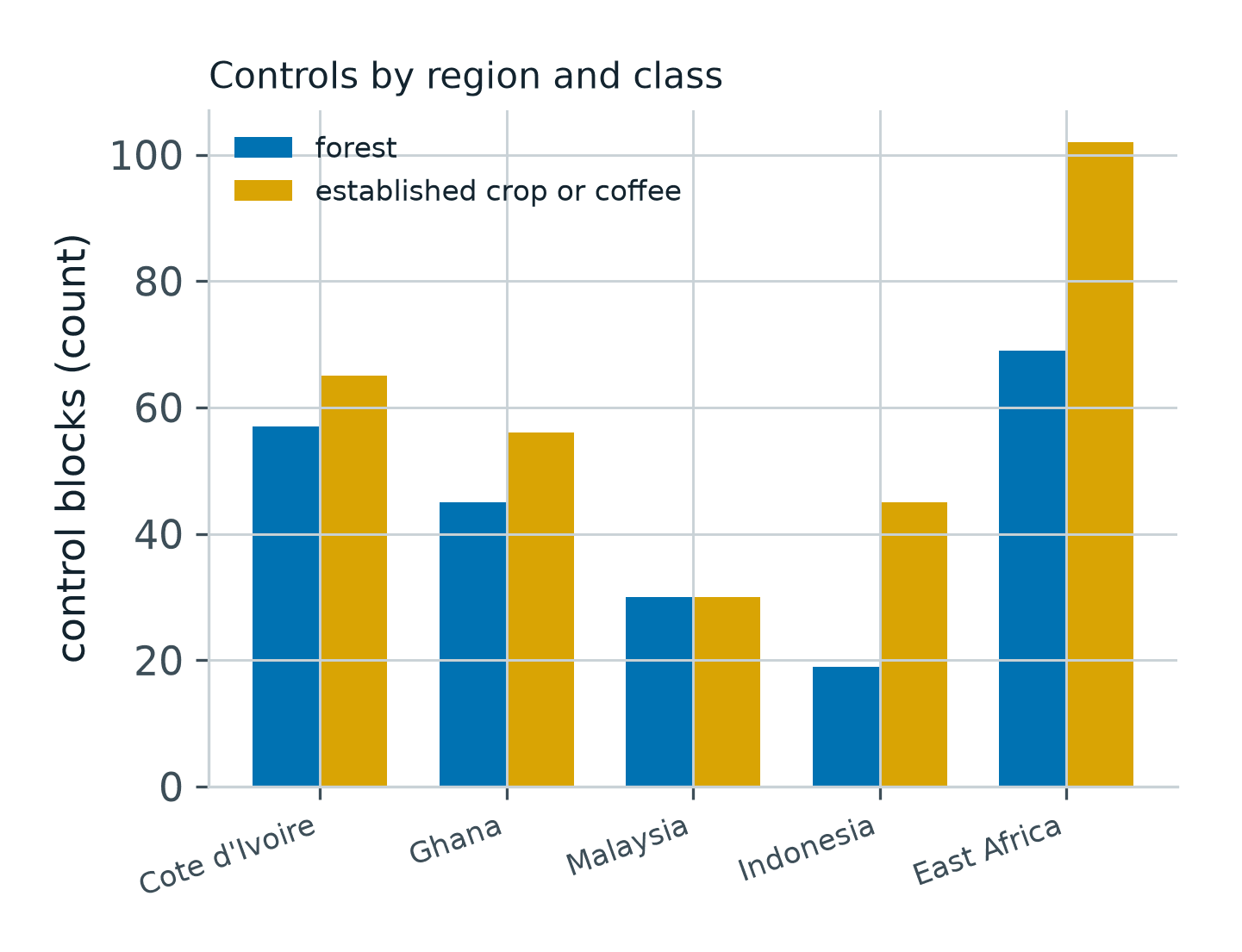
Before you rely on a plot record: 518 control blocks in five regions
We read 518 mapped boundaries of known cover the way we read a customer's plots. No natural forest block in any region was given a finding of an established stand: 0 of 220. On estates, the record reached findings on 51 of 65 blocks in Côte d'Ivoire.
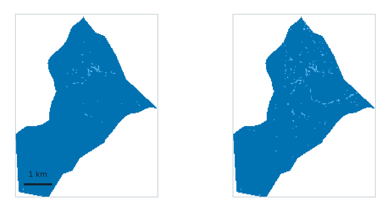
Harvest, not conversion: a Cameroonian cutting block read from 2020 to 2025
A tree-cover loss alert fires on a selective harvest and on a clearance alike. Read pixel by pixel from the JRC record, a real annual cutting area harvested in 2021 was still 98 per cent undisturbed forest at the end of 2025, with no ground cleared.
Send us ten flagged plots
Send the boundaries of ten plots your screen flagged. The record comes back within 48 hours as a PDF with the layers, each plot with its finding or its reason and next step.