
Before you rely on a plot record: 518 control blocks in five regions
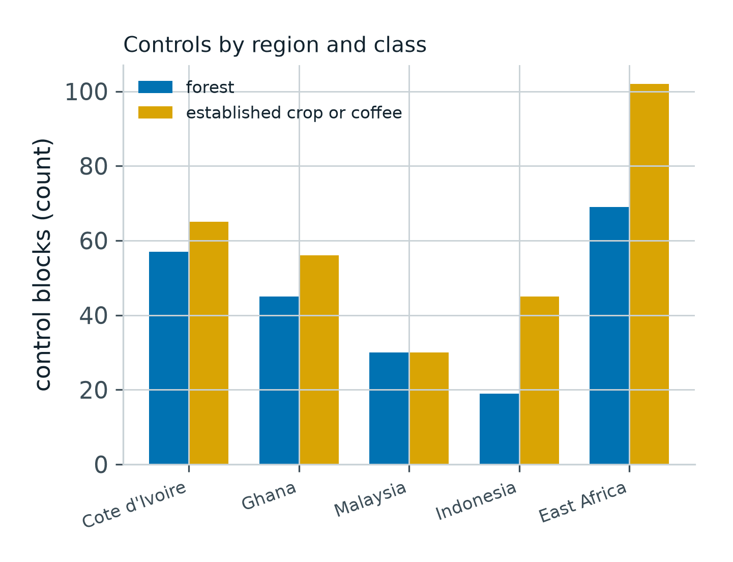
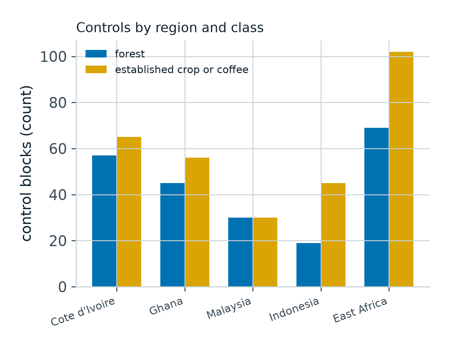
We read 518 mapped boundaries of known cover the way we read a customer's plots. No natural forest block in any region was given a finding of an established stand: 0 of 220. On estates, the record reached findings on 51 of 65 blocks in Côte d'Ivoire.
- Regions
- Côte d'Ivoire, Ghana, Malaysia, Indonesia, East Africa
- Control blocks
- 518
- Forest blocks
- 220, none given a finding
- Crop and coffee blocks
- 298
- Côte d'Ivoire crops
- 51 of 65 findings
- Indonesia oil palm
- 34 of 45 findings
- Kenya coffee estates
- 6 of 6 findings
- Product
- Plot evidence
The problem
An operator filing under the EUDR holds hundreds or thousands of plots, and needs to know how a per-plot record behaves on ground whose cover is already known.
What we did
Pre-registered control campaigns: 518 mapped boundaries of natural forest and established crop, read by the same record as a customer's plots.
The result
No forest block received a finding, 0 of 220. Estates reached findings in every region, and every count is printed with its denominator.
Overview
A per-plot record is only as useful as its behaviour on ground nobody disputes. Before an operator files with it, they need to know two things: does it ever give a finding to natural forest, and does it reach findings on the estates it is meant for.
We ran pre-registered control campaigns to answer both, in the five regions where the record issues findings: Côte d'Ivoire, Ghana, Malaysia, Indonesia, and East Africa for coffee. The controls are mapped boundaries of known cover, not operators' plots.
The challenge
The EUDR puts the obligation on the operator. A plot that was forest on 31 December 2020 and has since been planted cannot go into a statement, and the operator has to be able to show the evidence behind each plot they file.
A record that gives a finding to forest is worse than no record, because it puts a plot into a statement that should never be there. A record that never reaches a finding on a real estate is no use either. The controls measure both sides.
What we did
Each control boundary was read by the plot evidence record exactly as a customer's plot would be: every look in the open archive over the seasons before the cutoff, from Copernicus Sentinel-1 and Sentinel-2 and the Commission's 2020 forest maps, with national maps as the local reference where they are published.
The record either issued a finding, an established stand before 31 December 2020, or withheld one and said why. The pass lines were written down before any block was read, and every count is printed with its denominator.
What the record showed
| Region | Forest blocks given a finding | Crop blocks reaching a finding |
|---|---|---|
| Côte d'Ivoire | 0 of 57 | 51 of 65 established crop |
| Ghana | 0 of 45 | 12 of 16 oil palm; shaded cocoa goes to the archive review |
| Malaysia | 0 of 30 | 22 of 30 oil palm |
| Indonesia | 0 of 19 | 34 of 45 oil palm |
| East Africa | 0 of 69 | 6 of 6 Kenyan coffee estates, 19 of 21 Ugandan coffee, 61 of 75 blocks on one Tanzanian estate |
No natural forest control block in any region received a finding: 0 of 220. On the crop side the record reached findings on estates in every region, from 51 of 65 blocks in Côte d'Ivoire to 6 of 6 coffee estates in Kenya.
Where the open record could not tell a crop from forest, it withheld the finding and said why. A withheld plot is a designed outcome, and the archive review is the next step for it.
What it means
For an operator, these counts are the measured behaviour behind every plot record, printed with their denominators in the document's own calibration section. The finding applies to estates and sun-grown crops from four hectares in these five regions; smaller plots and plots elsewhere receive the same document as supporting evidence.
The determination stays with the operator. What the record gives them is a document per plot they can file beside the land title and the purchase records, and a measured answer when an inspector asks what stands behind it.
Run this on your own ground
Draw an area of interest, pick the dates, and the same analysis runs against the archive over your sites.
References
- Axine Labs (2026). Dated plot evidence for the EU Deforestation Regulation: a per-plot record with pre-registered controls. Section 4.
- Regulation (EU) 2023/1115 of the European Parliament and of the Council on deforestation-free products.
- European Commission Joint Research Centre. Global forest cover map for 2020. forest-observatory.ec.europa.eu
- European Space Agency. Copernicus Sentinel-1 and Sentinel-2 missions. sentinels.copernicus.eu
More case studies
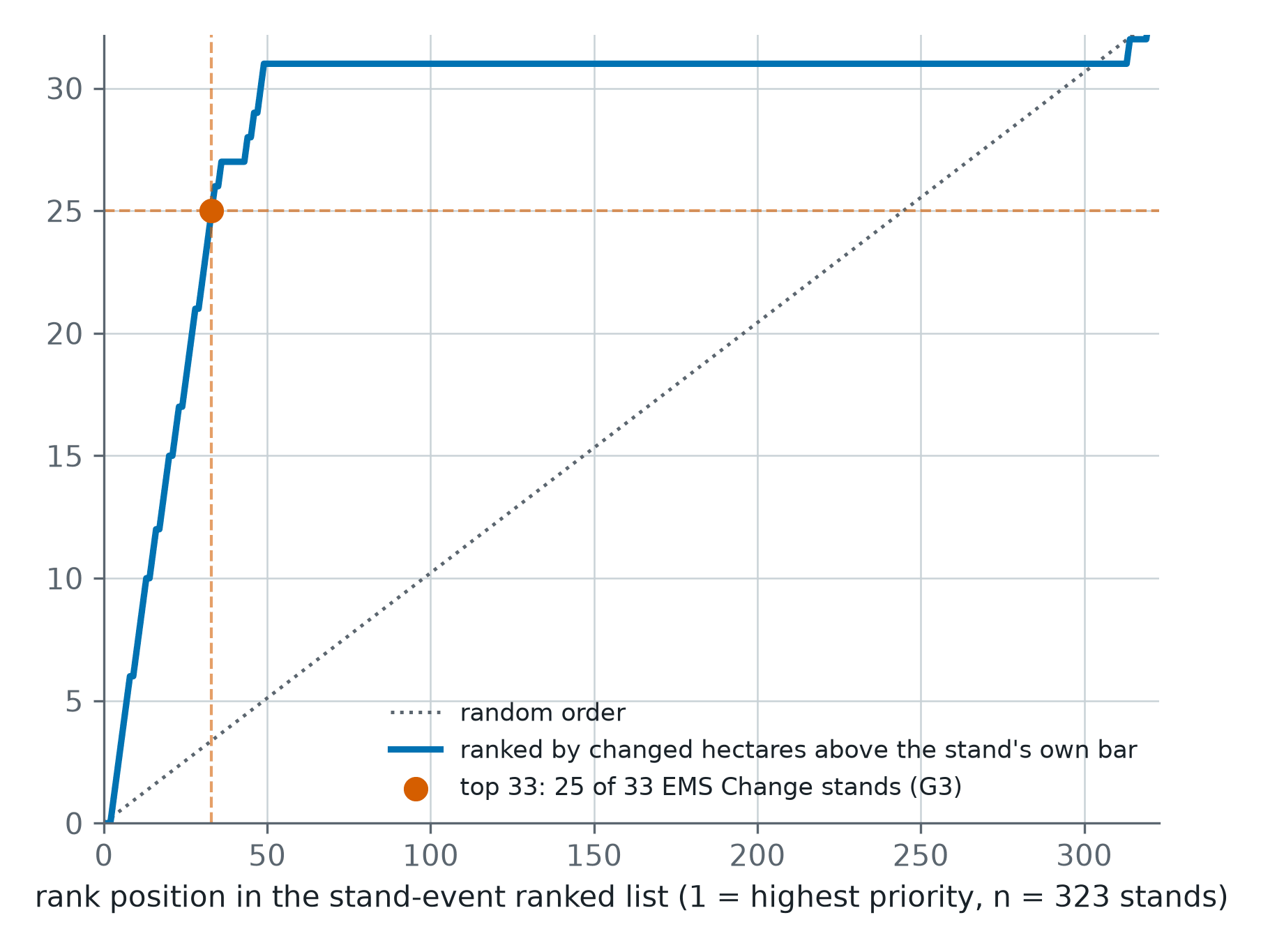
Storm Johannes: which stands to visit first, ranked from open imagery
After the December 2025 storm in central Sweden, 323 test stands were ranked from Sentinel-1 and Sentinel-2. Of the 33 the storm had changed, 25 sat in the top 33 of the list. Random order would have put three or four there.
Forty-three seasons of one Nebraska pivot, and its first zone map
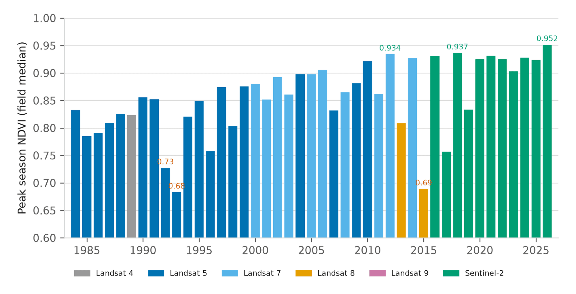
Before driving out, an agronomist wants to know whether this season is unusual for this field, not for the county. One centre pivot near Seward has a reading for every season from 1984 to 2026, and 2026 is the highest of them.
A Kansas season on one page, and the next two weeks of disease pressure
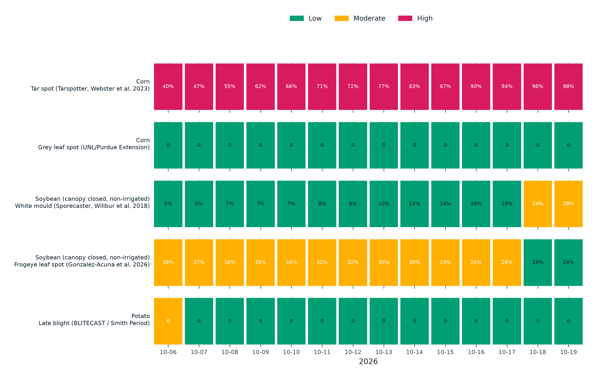
A 61-hectare corn pivot in western Kansas, 184 days into the 2026 season: 53 days at or above 35 °C against a normal of 27.8, more heat units than usual, and five published disease models run on the field's own forecast.